


Le ravin de Pihen 9.8km et 120m déniv

eaea7charles
User
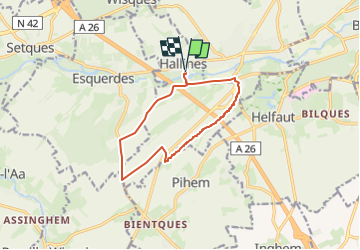

Length
9.8 km

Max alt
121 m

Uphill gradient
119 m
Km-Effort
11.4 km

Min alt
25 m

Downhill gradient
119 m
Boucle
Yes
Creation date :
2024-04-18 07:23:07.873
Updated on :
2024-04-18 07:25:19.417
2h35
Difficulty : Medium

FREE GPS app for hiking
 SityTrail
IGN / Geographical institutes
SityTrail Plus
The world is yours!
About
Trail Walking of 9.8 km to be discovered at Hauts-de-France, Pas-de-Calais, Hallines. This trail is proposed by eaea7charles.
Description
Au départ de Hallines
Positioning
Country:
France
Region :
Hauts-de-France
Department/Province :
Pas-de-Calais
Municipality :
Hallines
Location:
Unknown
Start:(Dec)
Start:(UTM)
444304 ; 5617530 (31U) N.
Comments