


Autour d'Ambleteuse

mathis01
User
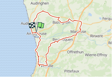

Length
33 km

Max alt
119 m

Uphill gradient
415 m
Km-Effort
38 km

Min alt
3 m

Downhill gradient
412 m
Boucle
Yes
Creation date :
2024-04-18 07:25:10.843
Updated on :
2024-04-18 09:19:55.19
8h42
Difficulty : Difficult
2h19
Difficulty : Difficult

FREE GPS app for hiking
 SityTrail
IGN / Geographical institutes
SityTrail Plus
The world is yours!
About
Trail On foot of 33 km to be discovered at Hauts-de-France, Pas-de-Calais, Ambleteuse. This trail is proposed by mathis01.
Positioning
Country:
France
Region :
Hauts-de-France
Department/Province :
Pas-de-Calais
Municipality :
Ambleteuse
Location:
Unknown
Start:(Dec)
Start:(UTM)
401877 ; 5629773 (31U) N.
Comments