


SityTrail - Dijon -> Beaune via Nuits st Goerges

apa
User
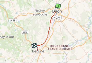

Length
49 km

Max alt
322 m

Uphill gradient
439 m
Km-Effort
55 km

Min alt
216 m

Downhill gradient
453 m
Boucle
No
Creation date :
2024-04-18 12:14:36.486
Updated on :
2024-04-18 12:14:59.054
0m
Difficulty : Very easy

FREE GPS app for hiking
 SityTrail
IGN / Geographical institutes
SityTrail Plus
The world is yours!
About
Trail Cycle of 49 km to be discovered at Bourgogne-Franche-Comté, Côte-d'Or, Dijon. This trail is proposed by apa.
Positioning
Country:
France
Region :
Bourgogne-Franche-Comté
Department/Province :
Côte-d'Or
Municipality :
Dijon
Location:
Unknown
Start:(Dec)
Start:(UTM)
652183 ; 5242469 (31T) N.
Comments