


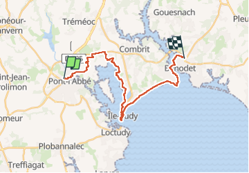
Pont l'Abbé à Bénodet

Axelloceane
User

Length
23 km

Max alt
35 m

Uphill gradient
177 m
Km-Effort
26 km

Min alt
-2 m

Downhill gradient
173 m
Boucle
No
Creation date :
2024-04-18 09:00:23.652
Updated on :
2024-04-22 18:59:59.297
4h59
Difficulty : Medium

FREE GPS app for hiking
 SityTrail
IGN / Geographical institutes
SityTrail Plus
The world is yours!
About
Trail Walking of 23 km to be discovered at Brittany, Finistère, Pont-l'Abbé. This trail is proposed by Axelloceane.
Description
Départ de Pont l'Abbé destination Bénodet en suivant le balisage du GR 34 .A Sainte Marine possibilité de prendre le bac pour rejoindre Bénodet .
Photos


Positioning
Country:
France
Region :
Brittany
Department/Province :
Finistère
Municipality :
Pont-l'Abbé
Location:
Unknown
Start:(Dec)
Start:(UTM)
408310 ; 5302305 (30T) N.
Comments