


Rustrel ocres

pb07
User
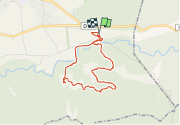

Length
4.2 km

Max alt
429 m

Uphill gradient
86 m
Km-Effort
5.3 km

Min alt
354 m

Downhill gradient
83 m
Boucle
Yes
Creation date :
2024-04-19 13:04:42.3
Updated on :
2024-04-19 14:35:54.739
1h30
Difficulty : Easy

FREE GPS app for hiking
 SityTrail
IGN / Geographical institutes
SityTrail Plus
The world is yours!
About
Trail Walking of 4.2 km to be discovered at Provence-Alpes-Côte d'Azur, Vaucluse, Rustrel. This trail is proposed by pb07.
Positioning
Country:
France
Region :
Provence-Alpes-Côte d'Azur
Department/Province :
Vaucluse
Municipality :
Rustrel
Location:
Unknown
Start:(Dec)
Start:(UTM)
700795 ; 4865944 (31T) N.
Comments