


MALTE 2024 / 05 Marsaxlokk to Marsaskalla

Michel1963
User GUIDE
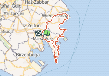

Length
19.6 km

Max alt
56 m

Uphill gradient
326 m
Km-Effort
24 km

Min alt
0 m

Downhill gradient
326 m
Boucle
Yes
Creation date :
2024-04-19 08:21:12.653
Updated on :
2024-04-22 09:50:24.537
5h19
Difficulty : Medium

FREE GPS app for hiking
 SityTrail
IGN / Geographical institutes
SityTrail Plus
The world is yours!
About
Trail Walking of 19.6 km to be discovered at South Eastern Region, Unknown, Marsaxlokk. This trail is proposed by Michel1963.
Photos


41 photos in total. Please click on a photo to see them all in the gallery.
Positioning
Country:
Malta
Region :
South Eastern Region
Department/Province :
Unknown
Municipality :
Marsaxlokk
Location:
Unknown
Start:(Dec)
Start:(UTM)
458890 ; 3966365 (33S) N.
Comments