


Quimper

Axelloceane
User
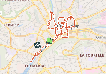

Length
7 km

Max alt
28 m

Uphill gradient
66 m
Km-Effort
7.9 km

Min alt
3 m

Downhill gradient
66 m
Boucle
Yes
Creation date :
2024-04-20 08:54:58.57
Updated on :
2024-04-22 19:13:32.166
1h47
Difficulty : Medium

FREE GPS app for hiking
 SityTrail
IGN / Geographical institutes
SityTrail Plus
The world is yours!
About
Trail Walking of 7 km to be discovered at Brittany, Finistère, Quimper. This trail is proposed by Axelloceane.
Description
Parcours découverte de Quimper .
Photos


Positioning
Country:
France
Region :
Brittany
Department/Province :
Finistère
Municipality :
Quimper
Location:
Unknown
Start:(Dec)
Start:(UTM)
417256 ; 5315998 (30T) N.
Comments