


Traversé Drôme par hexatrek etap8

taguette
User

Length
10.5 km

Max alt
195 m

Uphill gradient
186 m
Km-Effort
13 km

Min alt
62 m

Downhill gradient
202 m
Boucle
No
Creation date :
2024-04-20 10:25:25.494
Updated on :
2024-04-20 13:42:11.333
2h29
Difficulty : Difficult

FREE GPS app for hiking
 SityTrail
IGN / Geographical institutes
SityTrail Plus
The world is yours!
About
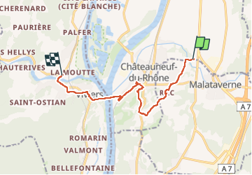
Trail Walking of 10.5 km to be discovered at Auvergne-Rhône-Alpes, Drôme, Châteauneuf-du-Rhône. This trail is proposed by taguette.
Positioning
Country:
France
Region :
Auvergne-Rhône-Alpes
Department/Province :
Drôme
Municipality :
Châteauneuf-du-Rhône
Location:
Unknown
Start:(Dec)
Start:(UTM)
638378 ; 4928349 (31T) N.
Comments