


Roussillon.

Renefrt
User
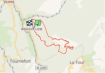

Length
8 km

Max alt
833 m

Uphill gradient
546 m
Km-Effort
15.3 km

Min alt
352 m

Downhill gradient
546 m
Boucle
Yes
Creation date :
2024-04-20 22:08:54.693
Updated on :
2024-04-20 22:08:58.402
3h28
Difficulty : Medium

FREE GPS app for hiking
 SityTrail
IGN / Geographical institutes
SityTrail Plus
The world is yours!
About
Trail Walking of 8 km to be discovered at Provence-Alpes-Côte d'Azur, Maritime Alps, La Tour. This trail is proposed by Renefrt.
Positioning
Country:
France
Region :
Provence-Alpes-Côte d'Azur
Department/Province :
Maritime Alps
Municipality :
La Tour
Location:
Unknown
Start:(Dec)
Start:(UTM)
352272 ; 4869120 (32T) N.
Comments