


Visite du Malesherbois 4

mathis01
User
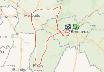

Length
16.9 km

Max alt
145 m

Uphill gradient
138 m
Km-Effort
18.7 km

Min alt
98 m

Downhill gradient
138 m
Boucle
Yes
Creation date :
2024-04-21 09:05:21.744
Updated on :
2024-11-12 08:05:43.695
4h14
Difficulty : Easy

FREE GPS app for hiking
 SityTrail
IGN / Geographical institutes
SityTrail Plus
The world is yours!
About
Trail On foot of 16.9 km to be discovered at Ile-de-France, Essonne, Champmotteux. This trail is proposed by mathis01.
Positioning
Country:
France
Region :
Ile-de-France
Department/Province :
Essonne
Municipality :
Champmotteux
Location:
Unknown
Start:(Dec)
Start:(UTM)
449604 ; 5354559 (31U) N.
Comments