


Autour de Wimereux

mathis01
User
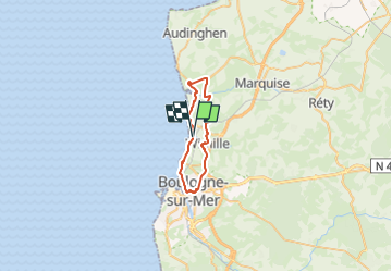

Length
27 km

Max alt
92 m

Uphill gradient
379 m
Km-Effort
32 km

Min alt
7 m

Downhill gradient
378 m
Boucle
Yes
Creation date :
2024-04-22 07:15:52.671
Updated on :
2024-04-22 07:50:21.773
1h54
Difficulty : Difficult

FREE GPS app for hiking
 SityTrail
IGN / Geographical institutes
SityTrail Plus
The world is yours!
About
Trail Road bike of 27 km to be discovered at Hauts-de-France, Pas-de-Calais, Wimereux. This trail is proposed by mathis01.
Positioning
Country:
France
Region :
Hauts-de-France
Department/Province :
Pas-de-Calais
Municipality :
Wimereux
Location:
Unknown
Start:(Dec)
Start:(UTM)
402095 ; 5625125 (31U) N.
Comments