


Touet sur Var autre parcours

Renefrt
User
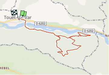

Length
11.7 km

Max alt
695 m

Uphill gradient
557 m
Km-Effort
19.1 km

Min alt
285 m

Downhill gradient
551 m
Boucle
Yes
Creation date :
2024-04-22 16:44:56.474
Updated on :
2024-04-22 16:45:01.775
4h19
Difficulty : Medium

FREE GPS app for hiking
 SityTrail
IGN / Geographical institutes
SityTrail Plus
The world is yours!
About
Trail Walking of 11.7 km to be discovered at Provence-Alpes-Côte d'Azur, Maritime Alps, Touët-sur-Var. This trail is proposed by Renefrt.
Positioning
Country:
France
Region :
Provence-Alpes-Côte d'Azur
Department/Province :
Maritime Alps
Municipality :
Touët-sur-Var
Location:
Unknown
Start:(Dec)
Start:(UTM)
340197 ; 4867966 (32T) N.
Comments