


grasse_digne_oct2023

aeldin
User
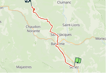

Length
19.6 km

Max alt
1225 m

Uphill gradient
852 m
Km-Effort
30 km

Min alt
719 m

Downhill gradient
593 m
Boucle
No
Creation date :
2024-04-23 17:49:05.8
Updated on :
2024-09-16 13:12:50.739
0m
Difficulty : Very easy

FREE GPS app for hiking
 SityTrail
IGN / Geographical institutes
SityTrail Plus
The world is yours!
About
Trail Equestrian of 19.6 km to be discovered at Provence-Alpes-Côte d'Azur, Alpes-de-Haute-Provence, Senez. This trail is proposed by aeldin.

Positioning
Country:
France
Region :
Provence-Alpes-Côte d'Azur
Department/Province :
Alpes-de-Haute-Provence
Municipality :
Senez
Location:
Unknown
Start:(Dec)
Start:(UTM)
291775 ; 4865611 (32T) N.
Comments