


le courrent

vincente204
User
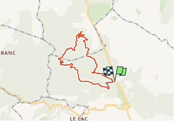

Length
15.5 km

Max alt
414 m

Uphill gradient
565 m
Km-Effort
23 km

Min alt
141 m

Downhill gradient
564 m
Boucle
Yes
Creation date :
2024-04-24 07:11:18.169
Updated on :
2024-04-24 14:15:55.886
4h45
Difficulty : Very difficult

FREE GPS app for hiking
 SityTrail
IGN / Geographical institutes
SityTrail Plus
The world is yours!
About
Trail Walking of 15.5 km to be discovered at Provence-Alpes-Côte d'Azur, Var, Sainte-Maxime. This trail is proposed by vincente204.
Description
difficile
Positioning
Country:
France
Region :
Provence-Alpes-Côte d'Azur
Department/Province :
Var
Municipality :
Sainte-Maxime
Location:
Unknown
Start:(Dec)
Start:(UTM)
304642 ; 4806158 (32T) N.
Comments