


Jeudi 25/04/24

cheepewa
User
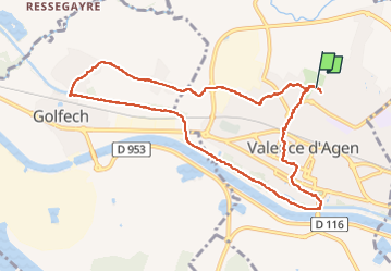

Length
10.4 km

Max alt
72 m

Uphill gradient
59 m
Km-Effort
11.1 km

Min alt
55 m

Downhill gradient
57 m
Boucle
Yes
Creation date :
2024-04-25 06:33:05.0
Updated on :
2024-04-25 08:54:33.05

FREE GPS app for hiking
 SityTrail
IGN / Geographical institutes
SityTrail Plus
The world is yours!
About
Trail of 10.4 km to be discovered at Occitania, Tarn-et-Garonne, Valence. This trail is proposed by cheepewa.
Description
Ch’tite ballade
Positioning
Country:
France
Region :
Occitania
Department/Province :
Tarn-et-Garonne
Municipality :
Valence
Location:
Unknown
Start:(Dec)
Start:(UTM)
331341 ; 4887128 (31T) N.
Comments