


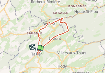
tavier reco
© OpenStreetMap contributors


2h33
Difficulty : Difficult


Length
10.2 km
Max alt
270 m
Uphill gradient
212 m
Km-Effort
13 km
Min alt
149 m
Downhill gradient
206 m
Boucle
Yes
Creation date :
2024-04-18 06:58:07.804
Updated on :
2024-04-25 09:32:57.169
2h33
Difficulty : Difficult
FREE GPS app for hiking
 SityTrail
IGN / Geographical institutes
SityTrail Plus
The world is yours!
About
Trail Walking of 10.2 km to be discovered at Wallonia, Liège, Anthisnes. This trail is proposed by houetphilippe@gmail.com.
Description
balade
Positioning
Country:
Belgium
Region :
Wallonia
Department/Province :
Liège
Municipality :
Anthisnes
Location:
Unknown
Start:(Dec)
Start:(UTM)
675260 ; 5596666 (31U) N.
Comments