


vieilley

MartinBraudThierry
User
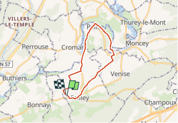

Length
11.1 km

Max alt
259 m

Uphill gradient
112 m
Km-Effort
12.6 km

Min alt
218 m

Downhill gradient
114 m
Boucle
Yes
Creation date :
2024-04-25 06:54:25.763
Updated on :
2024-04-25 09:46:18.086
2h37
Difficulty : Difficult

FREE GPS app for hiking
 SityTrail
IGN / Geographical institutes
SityTrail Plus
The world is yours!
About
Trail Walking of 11.1 km to be discovered at Bourgogne-Franche-Comté, Doubs, Vieilley. This trail is proposed by MartinBraudThierry.
Positioning
Country:
France
Region :
Bourgogne-Franche-Comté
Department/Province :
Doubs
Municipality :
Vieilley
Location:
Unknown
Start:(Dec)
Start:(UTM)
278769 ; 5246899 (32T) N.
Comments