


PAS DE CALAIS: WISSANT - CAP GRIS NEZ

djeepee74
User
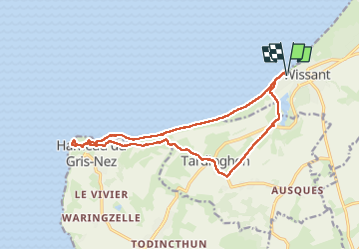

Length
14.8 km

Max alt
45 m

Uphill gradient
157 m
Km-Effort
16.9 km

Min alt
-2 m

Downhill gradient
157 m
Boucle
Yes
Creation date :
2024-04-25 07:39:02.389
Updated on :
2024-04-30 15:21:33.651
3h50
Difficulty : Medium

FREE GPS app for hiking
 SityTrail
IGN / Geographical institutes
SityTrail Plus
The world is yours!
About
Trail Walking of 14.8 km to be discovered at Hauts-de-France, Pas-de-Calais, Wissant. This trail is proposed by djeepee74.
Description
Boucle... live du 20230425
Positioning
Country:
France
Region :
Hauts-de-France
Department/Province :
Pas-de-Calais
Municipality :
Wissant
Location:
Unknown
Start:(Dec)
Start:(UTM)
405466 ; 5637910 (31U) N.
Comments