


Chesseix

Michelraimbault
User
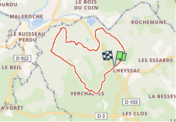

Length
7.6 km

Max alt
585 m

Uphill gradient
161 m
Km-Effort
9.8 km

Min alt
448 m

Downhill gradient
163 m
Boucle
Yes
Creation date :
2024-04-25 11:53:12.23
Updated on :
2024-04-25 14:41:01.033
2h19
Difficulty : Easy

FREE GPS app for hiking
 SityTrail
IGN / Geographical institutes
SityTrail Plus
The world is yours!
About
Trail Walking of 7.6 km to be discovered at Auvergne-Rhône-Alpes, Cantal, Vebret. This trail is proposed by Michelraimbault.
Positioning
Country:
France
Region :
Auvergne-Rhône-Alpes
Department/Province :
Cantal
Municipality :
Vebret
Location:
Unknown
Start:(Dec)
Start:(UTM)
461506 ; 5024060 (31T) N.
Comments