Trail Walking Marsanne - Fresneau-Alexis - Photo
 parastat
parastat

User

© OpenStreetMap contributors
Length
Length
8.9 km
Max alt
Max alt
586 m
Uphill gradient
Uphill gradient
335 m
Km-Effort
Km-Effort  
13.4 km
Min alt
Min alt
289 m
Downhill gradient
Downhill gradient
330 m
Boucle
Boucle
Yes
Creation date :
2024-04-25 11:19:52.402
Updated on :
2024-04-25 16:21:00.543

(0 Reviews)

Walking
Walking
3h25
Difficulty : Difficult

Scan this QR Code to open this trail in the SityTrail application

FREE GPS app for hiking

Logo SityTrail SityTrail

IGN / Geographical institutes

Download SityTrail from the App Store Download SityTrail from Google Play

Logo SityTrail SityTrail Plus

The world is yours!

Download SityTrail from the App Store Download SityTrail from Google Play Download SityTrail on Huawei AppGallery

About

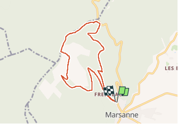
Trail Walking of 8.9 km to be discovered at Auvergne-Rhône-Alpes, Drôme, Marsanne. This trail is proposed by parastat.

Description

Je cherchais une alternative à l'ancien chemin remplacé par une méga piste DFCI.
Celle proposée évite les routes, mais pas les pistes traditionnelles.
Le chemin de montée part derrière l'église.
Le chemin de descente (1km- 200m de dén) est une sente visible mais peu tracée.
En bas de ce chemin, le plus simple est de prendre à droite et rejoindre le chemin de montée.

Elevation profile

Positioning

Country:
France
Region :
Auvergne-Rhône-Alpes
Department/Province :
Drôme
Municipality :
Marsanne
Location:
Unknown
Start:(UTM)
648394 ; 4945386 (31T) N.


Close
My subscriptions