


duniere

Joel26400
User

Length
20 km

Max alt
621 m

Uphill gradient
817 m
Km-Effort
31 km

Min alt
153 m

Downhill gradient
818 m
Boucle
Yes
Creation date :
2024-04-25 07:03:47.694
Updated on :
2024-04-25 14:55:55.665
5h47
Difficulty : Very difficult

FREE GPS app for hiking
 SityTrail
IGN / Geographical institutes
SityTrail Plus
The world is yours!
About
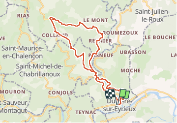
Trail Walking of 20 km to be discovered at Auvergne-Rhône-Alpes, Ardèche, Dunière-sur-Eyrieux. This trail is proposed by Joel26400.
Description
difficile
Positioning
Country:
France
Region :
Auvergne-Rhône-Alpes
Department/Province :
Ardèche
Municipality :
Dunière-sur-Eyrieux
Location:
Unknown
Start:(Dec)
Start:(UTM)
631029 ; 4964539 (31T) N.
Comments