


vigneu chevaux

jjjf01
User
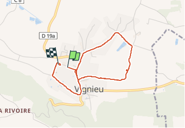

Length
3.6 km

Max alt
288 m

Uphill gradient
53 m
Km-Effort
4.3 km

Min alt
243 m

Downhill gradient
51 m
Boucle
Yes
Creation date :
2024-04-01 11:58:42.294
Updated on :
2024-04-25 17:03:43.576
1h26
Difficulty : Very easy

FREE GPS app for hiking
 SityTrail
IGN / Geographical institutes
SityTrail Plus
The world is yours!
About
Trail Walking of 3.6 km to be discovered at Auvergne-Rhône-Alpes, Isère, Vignieu. This trail is proposed by jjjf01.
Positioning
Country:
France
Region :
Auvergne-Rhône-Alpes
Department/Province :
Isère
Municipality :
Vignieu
Location:
Unknown
Start:(Dec)
Start:(UTM)
688772 ; 5055888 (31T) N.
Comments