


Boucle confirme 20k

ophness
User
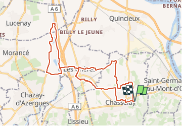

Length
19.8 km

Max alt
247 m

Uphill gradient
137 m
Km-Effort
22 km

Min alt
172 m

Downhill gradient
137 m
Boucle
Yes
Creation date :
2024-04-25 22:32:37.0
Updated on :
2024-04-25 22:32:38.446

FREE GPS app for hiking
 SityTrail
IGN / Geographical institutes
SityTrail Plus
The world is yours!
About
Trail of 19.8 km to be discovered at Auvergne-Rhône-Alpes, Rhône, Chasselay. This trail is proposed by ophness.
Positioning
Country:
France
Region :
Auvergne-Rhône-Alpes
Department/Province :
Rhône
Municipality :
Chasselay
Location:
Unknown
Start:(Dec)
Start:(UTM)
638225 ; 5081661 (31T) N.
Comments