


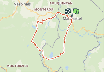
Lac de Saint-Andéol et Cascade du Déroc

raymondfn
User

Length
14.7 km

Max alt
1270 m

Uphill gradient
211 m
Km-Effort
17.5 km

Min alt
1150 m

Downhill gradient
214 m
Boucle
Yes
Creation date :
2024-04-26 14:57:27.969
Updated on :
2024-05-09 16:12:06.749
3h59
Difficulty : Easy

FREE GPS app for hiking
 SityTrail
IGN / Geographical institutes
SityTrail Plus
The world is yours!
About
Trail On foot of 14.7 km to be discovered at Occitania, Lozère, Marchastel. This trail is proposed by raymondfn.
Points of interest


Positioning
Country:
France
Region :
Occitania
Department/Province :
Lozère
Municipality :
Marchastel
Location:
Unknown
Start:(Dec)
Start:(UTM)
508426 ; 4944170 (31T) N.
Comments