


En passant par Beauregard et les coutelleries depuis Laguiole

raymondfn
User
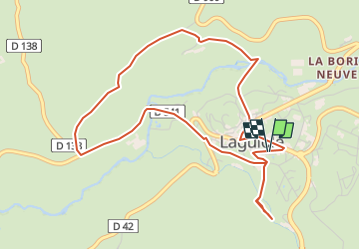

Length
5.5 km

Max alt
1028 m

Uphill gradient
153 m
Km-Effort
7.5 km

Min alt
949 m

Downhill gradient
152 m
Boucle
Yes
Creation date :
2024-04-26 15:08:12.675
Updated on :
2024-05-09 16:06:35.33
1h42
Difficulty : Medium

FREE GPS app for hiking
 SityTrail
IGN / Geographical institutes
SityTrail Plus
The world is yours!
About
Trail Walking of 5.5 km to be discovered at Occitania, Aveyron, Laguiole. This trail is proposed by raymondfn.
Points of interest


Positioning
Country:
France
Region :
Occitania
Department/Province :
Aveyron
Municipality :
Laguiole
Location:
Unknown
Start:(Dec)
Start:(UTM)
487981 ; 4947784 (31T) N.
Comments