Trail Walking Laxou - Laxou le Haut du Lièvre - Photo

Laxou le Haut du Lièvre

© OpenStreetMap contributors
Length
Length
12.9 km
Max alt
Max alt
363 m
Uphill gradient
Uphill gradient
248 m
Km-Effort
Km-Effort  
16.2 km
Min alt
Min alt
239 m
Downhill gradient
Downhill gradient
253 m
Boucle
Boucle
Yes
Creation date :
2015-04-03 00:00:00.0
Updated on :
2015-04-03 00:00:00.0

(0 Reviews)

Walking
Walking
3h29
Difficulty : Easy

Scan this QR Code to open this trail in the SityTrail application

FREE GPS app for hiking

Logo SityTrail SityTrail

IGN / Geographical institutes

Download SityTrail from the App Store Download SityTrail from Google Play

Logo SityTrail SityTrail World

The world is yours!

Download SityTrail from the App Store Download SityTrail from Google Play Download SityTrail on Huawei AppGallery

About

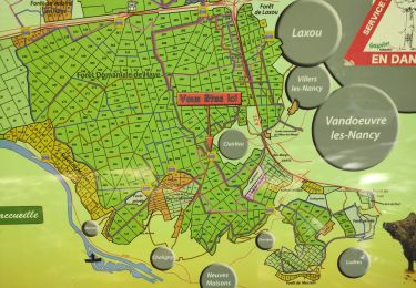
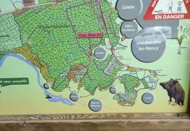
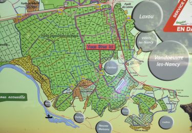
Trail Walking of 12.9 km to be discovered at Grand Est, Meurthe-et-Moselle, Laxou. This trail is proposed by joelclaudel.

Description

Départ place de la Liberté (cimetière de Laxou)
Rando fiche n°12 du guide FFRP le Grand Nancy à Pied.
Variante possible plus courte au niveau de St Jacques (en rose sur la carte)

Elevation profile

Positioning

Country:
France
Region :
Grand Est
Department/Province :
Meurthe-et-Moselle
Municipality :
Laxou
Location:
Unknown
Start:(UTM)
289812 ; 5396587 (32U) N.

Trails nearby

Trail On foot Champigneulles - Circuit G - Photo
On foot
PRO

On foot

Medium
Champigneulles, Grand Est, Meurthe-et-Moselle, France
18.7 km | 24 km-effort
5h 24min
No
Trail On foot Champigneulles - Circuit du Val Saint-Barthélémy - Photo
On foot
PRO

On foot

Easy
Champigneulles, Grand Est, Meurthe-et-Moselle, France
7 km | 8.6 km-effort
1h 57min
Yes
Trail On foot Champigneulles - Circuit du Noirval - Photo
On foot
PRO

On foot

Easy
Champigneulles, Grand Est, Meurthe-et-Moselle, France
11.1 km | 13.5 km-effort
3h 4min
Yes
Trail Walking Nancy - Ma dernière avant opération  - Photo
Walking
Toyot 8

Walking

Very difficult
(1)
Nancy, Grand Est, Meurthe-et-Moselle, France
22 km | 25 km-effort
4h 12min
Yes
Trail Walking Vandœuvre-lès-Nancy - Randonnée USEP 2023 - Photo
Walking
nicolas54230

Walking

Difficult
(1)
Vandœuvre-lès-Nancy, Grand Est, Meurthe-et-Moselle, France
11.7 km | 15.2 km-effort
3h 27min
No
Trail Walking Nancy - Ma rando du jour - Photo
Walking
Toyot 8

Walking

Difficult
Nancy, Grand Est, Meurthe-et-Moselle, France
35 km | 41 km-effort
5h 55min
Yes
Trail Walking Nancy - Nancy Gondreville Nancy - Photo
Walking
Toyot 8

Walking

Difficult
Nancy, Grand Est, Meurthe-et-Moselle, France
64 km | 74 km-effort
10h 57min
Yes
Trail Walking Nancy - Nancy Saizeray Jaillon Pierre la Treiche Marion Nancy  - Photo
Walking
Toyot 8

Walking

Difficult
Nancy, Grand Est, Meurthe-et-Moselle, France
73 km | 85 km-effort
12h 13min
Yes
Trail Walking Villers-lès-Nancy - RANDO DUO AVEC ALEXIS - Photo
Walking
Toyot 8

Walking

Difficult
(1)
Villers-lès-Nancy, Grand Est, Meurthe-et-Moselle, France
38 km | 45 km-effort
10h 19min
No


Close
My subscriptions