


mérindole canal

jacques.seux
User
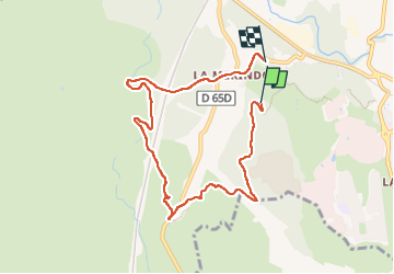

Length
8.1 km

Max alt
180 m

Uphill gradient
109 m
Km-Effort
9.6 km

Min alt
106 m

Downhill gradient
120 m
Boucle
No
Creation date :
2024-04-27 08:16:36.687
Updated on :
2024-04-27 09:56:40.779
1h39
Difficulty : Very easy

FREE GPS app for hiking
 SityTrail
IGN / Geographical institutes
SityTrail Plus
The world is yours!
About
Trail Nordic walking of 8.1 km to be discovered at Provence-Alpes-Côte d'Azur, Bouches-du-Rhône, Aix-en-Provence. This trail is proposed by jacques.seux.
Positioning
Country:
France
Region :
Provence-Alpes-Côte d'Azur
Department/Province :
Bouches-du-Rhône
Municipality :
Aix-en-Provence
Location:
Unknown
Start:(Dec)
Start:(UTM)
688420 ; 4818872 (31T) N.
Comments