


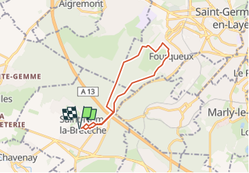
Fouqueux

Rando MLC
User

Length
10.9 km

Max alt
198 m

Uphill gradient
214 m
Km-Effort
13.7 km

Min alt
83 m

Downhill gradient
213 m
Boucle
Yes
Creation date :
2024-04-27 12:30:36.529
Updated on :
2024-04-27 12:41:21.545
3h07
Difficulty : Difficult

FREE GPS app for hiking
 SityTrail
IGN / Geographical institutes
SityTrail Plus
The world is yours!
About
Trail Walking of 10.9 km to be discovered at Ile-de-France, Yvelines, Saint-Nom-la-Bretèche. This trail is proposed by Rando MLC.
Positioning
Country:
France
Region :
Ile-de-France
Department/Province :
Yvelines
Municipality :
Saint-Nom-la-Bretèche
Location:
Unknown
Start:(Dec)
Start:(UTM)
428060 ; 5412646 (31U) N.
Comments