


St Laurent le Minier

ARPF
User
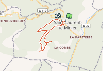

Length
6.2 km

Max alt
635 m

Uphill gradient
495 m
Km-Effort
12.7 km

Min alt
189 m

Downhill gradient
457 m
Boucle
Yes
Creation date :
2015-04-03 00:00:00.0
Updated on :
2015-04-03 00:00:00.0
2h36
Difficulty : Medium

FREE GPS app for hiking
 SityTrail
IGN / Geographical institutes
SityTrail Plus
The world is yours!
About
Trail Walking of 6.2 km to be discovered at Occitania, Gard, Saint-Laurent-le-Minier. This trail is proposed by ARPF.
Description
Pour séjour Cévennes -Jacques S 03/04/2015
Positioning
Country:
France
Region :
Occitania
Department/Province :
Gard
Municipality :
Saint-Laurent-le-Minier
Location:
Unknown
Start:(Dec)
Start:(UTM)
552537 ; 4864541 (31T) N.
Comments