


Saint Barnabé - Puy de Tourettes

jlrayon
User
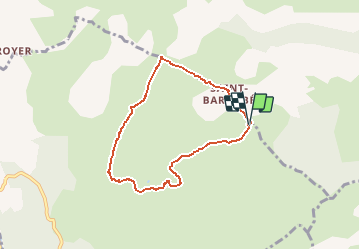

Length
7 km

Max alt
1020 m

Uphill gradient
123 m
Km-Effort
8.7 km

Min alt
933 m

Downhill gradient
126 m
Boucle
Yes
Creation date :
2017-04-03 00:00:00.0
Updated on :
2017-04-03 00:00:00.0
2h14
Difficulty : Difficult

FREE GPS app for hiking
 SityTrail
IGN / Geographical institutes
SityTrail Plus
The world is yours!
About
Trail Walking of 7 km to be discovered at Provence-Alpes-Côte d'Azur, Maritime Alps, Courmes. This trail is proposed by jlrayon.
Description
Plateau de Saint Barnabé, Puy de Tourrettes, retour par la Sambre Brune


Positioning
Country:
France
Region :
Provence-Alpes-Côte d'Azur
Department/Province :
Maritime Alps
Municipality :
Courmes
Location:
Unknown
Start:(Dec)
Start:(UTM)
342384 ; 4847115 (32T) N.
Comments