Trail Walking Château-Thierry - Les Vignes Castelles trace du 28-04-2024 - Photo

Les Vignes Castelles trace du 28-04-2024

© OpenStreetMap contributors
Length
Length
12.6 km
Max alt
Max alt
190 m
Uphill gradient
Uphill gradient
282 m
Km-Effort
Km-Effort  
16.4 km
Min alt
Min alt
57 m
Downhill gradient
Downhill gradient
281 m
Boucle
Boucle
Yes
Creation date :
2024-04-28 11:31:35.523
Updated on :
2024-04-28 20:33:56.376

(0 Reviews)

Walking
Walking
3h43
Difficulty : Difficult

Scan this QR Code to open this trail in the SityTrail application

FREE GPS app for hiking

Logo SityTrail SityTrail

IGN / Geographical institutes

Download SityTrail from the App Store Download SityTrail from Google Play

Logo SityTrail SityTrail World

The world is yours!

Download SityTrail from the App Store Download SityTrail from Google Play Download SityTrail on Huawei AppGallery

About

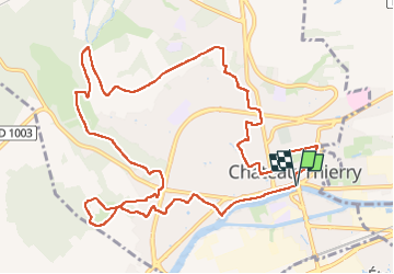
Trail Walking of 12.6 km to be discovered at Hauts-de-France, Aisne, Château-Thierry. This trail is proposed by VANDERPUTTENMi.

Description

Un circuit exclusivement communal depuis la maison du tourisme "les Portes de la Champagne".
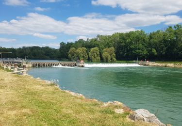
De la rivière Marne au monument Américain, du marais aux vignes de Vincelles, des vignes des Blanchards au vieux Château.
De belles vues sur la vallée et la ville depuis les hauteurs.
Un patrimoine intra-muros à découvrir en arpentant des sentes d'un quartier à l'autre.

Elevation profile

Photos

Positioning

Country:
France
Region :
Hauts-de-France
Department/Province :
Aisne
Municipality :
Château-Thierry
Location:
Unknown
Start:(UTM)
529443 ; 5432460 (31U) N.

Trails nearby

Trail Running Verdilly - Verdilly Balcons de la Marne  - Photo
Running
nicochproun

Running

Medium
(1)
Verdilly, Hauts-de-France, Aisne, France
32 km | 41 km-effort
Unknown
Yes
Trail Walking Château-Thierry - Le chemin de St Colomban en IDF Etape 1 Chateau Thierry - Nanteuil sur Marne - Photo
Walking
chessyca

Walking

Very difficult
Château-Thierry, Hauts-de-France, Aisne, France
35 km | 44 km-effort
7h 12min
No
Trail Walking Château-Thierry - Les vignes Castelles - version 8 km - Photo
Walking
VANDERPUTTENMi

Walking

Medium
Château-Thierry, Hauts-de-France, Aisne, France
8.2 km | 10.3 km-effort
2h 20min
Yes
Trail Walking Azy-sur-Marne - BONNEIL - Photo
Walking
explorateur

Walking

Medium
(1)
Azy-sur-Marne, Hauts-de-France, Aisne, France
8.7 km | 10.8 km-effort
2h 21min
Yes
Trail Walking Nesles-la-Montagne - Nesles la Montagne du 02/06/2020 - Photo
Walking
VANDERPUTTENMi

Walking

Very easy
Nesles-la-Montagne, Hauts-de-France, Aisne, France
8.6 km | 11.1 km-effort
1h 45min
Yes
Trail Mountain bike Château-Thierry - Château / Mont St Père / Azy / Château - Photo
Mountain bike
VANDERPUTTENMi

Mountain bike

Very easy
Château-Thierry, Hauts-de-France, Aisne, France
33 km | 35 km-effort
1h 40min
Yes
Trail Walking Château-Thierry - Château - Aulnois - Château du 26/05/2020 - Photo
Walking
VANDERPUTTENMi

Walking

Very easy
Château-Thierry, Hauts-de-France, Aisne, France
9.2 km | 11.1 km-effort
2h 4min
Yes
Trail Walking Château-Thierry - La cote 204 - Photo
Walking

Walking

Very easy
Château-Thierry, Hauts-de-France, Aisne, France
9.9 km | 12.7 km-effort
Unknown
Yes
Trail Walking Azy-sur-Marne - La corniche d'Azy - Photo
Walking

Walking

Very easy
Azy-sur-Marne, Hauts-de-France, Aisne, France
10.6 km | 14.2 km-effort
Unknown
Yes


Close
My subscriptions