


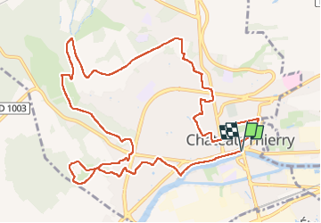
Les Vignes Castelles trace du 28-04-2024

VANDERPUTTENMi
User GUIDE


3h43
Difficulty : Difficult

FREE GPS app for hiking
 SityTrail
IGN / Geographical institutes
SityTrail Plus
The world is yours!
About
Trail Walking of 12.6 km to be discovered at Hauts-de-France, Aisne, Château-Thierry. This trail is proposed by VANDERPUTTENMi.
Description
Un circuit exclusivement communal depuis la maison du tourisme "les Portes de la Champagne".
De la rivière Marne au monument Américain, du marais aux vignes de Vincelles, des vignes des Blanchards au vieux Château.
De belles vues sur la vallée et la ville depuis les hauteurs.
Un patrimoine intra-muros à découvrir en arpentant des sentes d'un quartier à l'autre.
Photos


Positioning
Comments