


Anse à l’eau

sameja
User
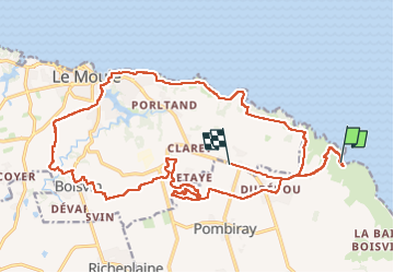

Length
40 km

Max alt
54 m

Uphill gradient
419 m
Km-Effort
46 km

Min alt
-4 m

Downhill gradient
386 m
Boucle
No
Creation date :
2024-04-21 11:25:33.0
Updated on :
2024-04-28 21:18:27.473
4h25
Difficulty : Medium

FREE GPS app for hiking
 SityTrail
IGN / Geographical institutes
SityTrail Plus
The world is yours!
About
Trail Mountain bike of 40 km to be discovered at Guadeloupe, Unknown, Saint-François. This trail is proposed by sameja.
Description
La boucle
Photos


Positioning
Country:
France
Region :
Guadeloupe
Department/Province :
Unknown
Municipality :
Saint-François
Location:
Unknown
Start:(Dec)
Start:(UTM)
685085 ; 1803550 (20Q) N.
Comments