


Mougin - parc de la Valmasque

GeorgesV.
User
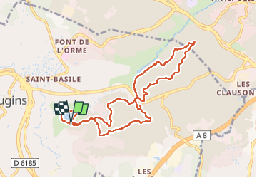

Length
10.8 km

Max alt
237 m

Uphill gradient
264 m
Km-Effort
14.3 km

Min alt
159 m

Downhill gradient
252 m
Boucle
Yes
Creation date :
2024-04-29 06:52:36.0
Updated on :
2024-04-29 10:34:08.451

FREE GPS app for hiking
 SityTrail
IGN / Geographical institutes
SityTrail Plus
The world is yours!
About
Trail of 10.8 km to be discovered at Provence-Alpes-Côte d'Azur, Maritime Alps, Mougins. This trail is proposed by GeorgesV..
Positioning
Country:
France
Region :
Provence-Alpes-Côte d'Azur
Department/Province :
Maritime Alps
Municipality :
Mougins
Location:
Unknown
Start:(Dec)
Start:(UTM)
339588 ; 4829004 (32T) N.
Comments