


Ardèche étap5

taguette
User
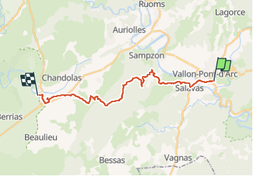

Length
22 km

Max alt
366 m

Uphill gradient
460 m
Km-Effort
28 km

Min alt
76 m

Downhill gradient
457 m
Boucle
No
Creation date :
2024-04-29 06:34:14.249
Updated on :
2024-04-29 13:10:18.189
6h33
Difficulty : Very difficult

FREE GPS app for hiking
 SityTrail
IGN / Geographical institutes
SityTrail Plus
The world is yours!
About
Trail Walking of 22 km to be discovered at Auvergne-Rhône-Alpes, Ardèche, Vallon-Pont-d'Arc. This trail is proposed by taguette.
Positioning
Country:
France
Region :
Auvergne-Rhône-Alpes
Department/Province :
Ardèche
Municipality :
Vallon-Pont-d'Arc
Location:
Unknown
Start:(Dec)
Start:(UTM)
611646 ; 4917249 (31T) N.
Comments