


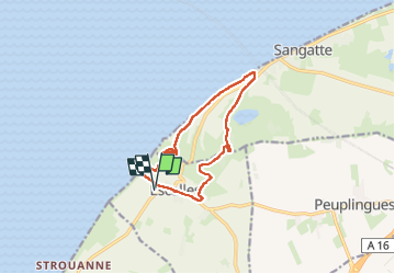
Cap Blanc Nez

i20
User

Length
11 km

Max alt
144 m

Uphill gradient
255 m
Km-Effort
14.4 km

Min alt
7 m

Downhill gradient
256 m
Boucle
Yes
Creation date :
2024-04-29 13:17:56.897
Updated on :
2024-04-29 15:51:00.372
2h32
Difficulty : Medium

FREE GPS app for hiking
 SityTrail
IGN / Geographical institutes
SityTrail Plus
The world is yours!
About
Trail Walking of 11 km to be discovered at Hauts-de-France, Pas-de-Calais, Escalles. This trail is proposed by i20.
Positioning
Country:
France
Region :
Hauts-de-France
Department/Province :
Pas-de-Calais
Municipality :
Escalles
Location:
Unknown
Start:(Dec)
Start:(UTM)
409139 ; 5641509 (31U) N.
Comments