Trail Other activity Unknown - Le Pouce  - Photo
© OpenStreetMap contributors
Length
Length
12 km
Max alt
Max alt
757 m
Uphill gradient
Uphill gradient
809 m
Km-Effort
Km-Effort  
23 km
Min alt
Min alt
64 m
Downhill gradient
Downhill gradient
809 m
Boucle
Boucle
Yes
Creation date :
2015-04-03 00:00:00.0
Updated on :
2015-04-03 00:00:00.0

(0 Reviews)

Other activity
Other activity
--
Difficulty : Unknown

Scan this QR Code to open this trail in the SityTrail application

FREE GPS app for hiking

Logo SityTrail SityTrail

IGN / Geographical institutes

Download SityTrail from the App Store Download SityTrail from Google Play

Logo SityTrail SityTrail World

The world is yours!

Download SityTrail from the App Store Download SityTrail from Google Play Download SityTrail on Huawei AppGallery

About

Trail Other activity of 12 km to be discovered at Port Louis. This trail is proposed by njourdain.

Description

Easy but comparatively long hike along a visible and partly sing-posted path starting in Port Louis. Le Pouce can also be easily approached from Moka.

Elevation profile

Positioning

Country:
Mauritius
Region :
Port Louis
Department/Province :
Unknown
Municipality :
Unknown
Location:
Unknown
Start:(UTM)
553902 ; 7768938 (40K) S.

Trails nearby

Trail Other activity  - Plateau du Pouce - Le Dauguet - Vallée des prêtres - Col Pouce-Pieter Both - Photo
Other activity
njourdain

Other activity

Very easy
, Moka, , Mauritius
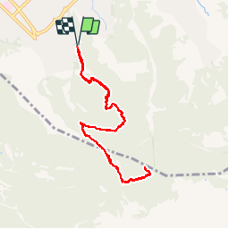
18.5 km | 32 km-effort
Unknown
Yes


Close
My subscriptions