


2024 04 30

lr80
User
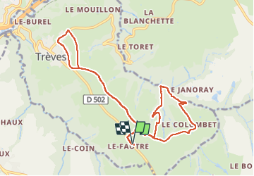

Length
10.8 km

Max alt
394 m

Uphill gradient
181 m
Km-Effort
13.2 km

Min alt
287 m

Downhill gradient
182 m
Boucle
Yes
Creation date :
2024-04-30 06:02:40.514
Updated on :
2024-04-30 08:12:56.645
1h57
Difficulty : Easy

FREE GPS app for hiking
 SityTrail
IGN / Geographical institutes
SityTrail Plus
The world is yours!
About
Trail Walking of 10.8 km to be discovered at Auvergne-Rhône-Alpes, Rhône, Trèves. This trail is proposed by lr80.
Description
tour trèves variante
Positioning
Country:
France
Region :
Auvergne-Rhône-Alpes
Department/Province :
Rhône
Municipality :
Trèves
Location:
Unknown
Start:(Dec)
Start:(UTM)
632463 ; 5042539 (31T) N.
Comments