


Fort Mahon

i20
User
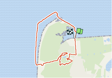

Length
8.5 km

Max alt
18 m

Uphill gradient
29 m
Km-Effort
8.9 km

Min alt
0 m

Downhill gradient
29 m
Boucle
Yes
Creation date :
2024-04-30 08:54:39.149
Updated on :
2024-04-30 11:04:59.138
2h10
Difficulty : Medium

FREE GPS app for hiking
 SityTrail
IGN / Geographical institutes
SityTrail Plus
The world is yours!
About
Trail Walking of 8.5 km to be discovered at Hauts-de-France, Somme, Fort-Mahon-Plage. This trail is proposed by i20.
Positioning
Country:
France
Region :
Hauts-de-France
Department/Province :
Somme
Municipality :
Fort-Mahon-Plage
Location:
Unknown
Start:(Dec)
Start:(UTM)
398358 ; 5579470 (31U) N.
Comments