


Saint Étienne centre ville

MAUVAGE Patrick
User
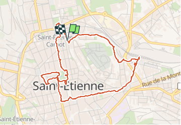

Length
5.7 km

Max alt
536 m

Uphill gradient
77 m
Km-Effort
6.8 km

Min alt
504 m

Downhill gradient
75 m
Boucle
Yes
Creation date :
2024-05-01 09:11:07.0
Updated on :
2024-05-04 20:33:50.941
1h32
Difficulty : Medium

FREE GPS app for hiking
 SityTrail
IGN / Geographical institutes
SityTrail Plus
The world is yours!
About
Trail Walking of 5.7 km to be discovered at Auvergne-Rhône-Alpes, Loire, Saint-Étienne. This trail is proposed by MAUVAGE Patrick.
Positioning
Country:
France
Region :
Auvergne-Rhône-Alpes
Department/Province :
Loire
Municipality :
Saint-Étienne
Location:
Unknown
Start:(Dec)
Start:(UTM)
608481 ; 5033392 (31T) N.
Comments