


tullins parmi l'achat taaues

BELLETGE
User
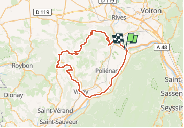

Length
62 km

Max alt
724 m

Uphill gradient
1094 m
Km-Effort
77 km

Min alt
178 m

Downhill gradient
1094 m
Boucle
Yes
Creation date :
2024-05-01 08:14:24.77
Updated on :
2024-05-01 12:46:38.161
3h49
Difficulty : Easy

FREE GPS app for hiking
 SityTrail
IGN / Geographical institutes
SityTrail Plus
The world is yours!
About
Trail Road bike of 62 km to be discovered at Auvergne-Rhône-Alpes, Isère, Tullins. This trail is proposed by BELLETGE.
Positioning
Country:
France
Region :
Auvergne-Rhône-Alpes
Department/Province :
Isère
Municipality :
Tullins
Location:
Unknown
Start:(Dec)
Start:(UTM)
697780 ; 5018096 (31T) N.
Comments