


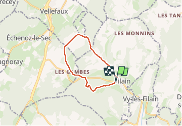
Filain-saint Anne-Filain

nicolasdresse
User

Length
9.2 km

Max alt
414 m

Uphill gradient
193 m
Km-Effort
11.7 km

Min alt
270 m

Downhill gradient
193 m
Boucle
Yes
Creation date :
2024-05-01 09:21:34.0
Updated on :
2024-05-01 16:02:01.379
2h52
Difficulty : Medium

FREE GPS app for hiking
 SityTrail
IGN / Geographical institutes
SityTrail Plus
The world is yours!
About
Trail Walking of 9.2 km to be discovered at Bourgogne-Franche-Comté, Haute-Saône, Filain. This trail is proposed by nicolasdresse.
Positioning
Country:
France
Region :
Bourgogne-Franche-Comté
Department/Province :
Haute-Saône
Municipality :
Filain
Location:
Unknown
Start:(Dec)
Start:(UTM)
287668 ; 5266737 (32T) N.
Comments