


Chaudes-Aigues-Montallat

raymondfn
User
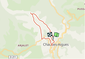

Length
6 km

Max alt
933 m

Uphill gradient
226 m
Km-Effort
9.1 km

Min alt
760 m

Downhill gradient
227 m
Boucle
Yes
Creation date :
2024-05-01 19:02:18.718
Updated on :
2024-05-30 13:12:52.671
2h03
Difficulty : Medium

FREE GPS app for hiking
 SityTrail
IGN / Geographical institutes
SityTrail Plus
The world is yours!
About
Trail Walking of 6 km to be discovered at Auvergne-Rhône-Alpes, Cantal, Chaudes-Aigues. This trail is proposed by raymondfn.

Positioning
Country:
France
Region :
Auvergne-Rhône-Alpes
Department/Province :
Cantal
Municipality :
Chaudes-Aigues
Location:
Unknown
Start:(Dec)
Start:(UTM)
500207 ; 4966926 (31T) N.
Comments