


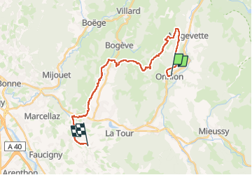
Onnion Course à pied

HG74250
User

Length
24 km

Max alt
1322 m

Uphill gradient
730 m
Km-Effort
35 km

Min alt
578 m

Downhill gradient
891 m
Boucle
No
Creation date :
2024-05-02 05:06:28.086
Updated on :
2024-05-02 08:52:41.871
0m
Difficulty : Medium

FREE GPS app for hiking
 SityTrail
IGN / Geographical institutes
SityTrail Plus
The world is yours!
About
Trail Trail of 24 km to be discovered at Auvergne-Rhône-Alpes, Upper Savoy, Onnion. This trail is proposed by HG74250.
Positioning
Country:
France
Region :
Auvergne-Rhône-Alpes
Department/Province :
Upper Savoy
Municipality :
Onnion
Location:
Unknown
Start:(Dec)
Start:(UTM)
305594 ; 5116278 (32T) N.
Comments