


Pichauris

fhascoet
User
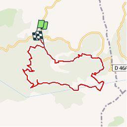

Length
9.2 km

Max alt
583 m

Uphill gradient
356 m
Km-Effort
13.9 km

Min alt
308 m

Downhill gradient
343 m
Boucle
No
Creation date :
2015-04-05 00:00:00.0
Updated on :
2015-04-05 00:00:00.0
3h00
Difficulty : Easy

FREE GPS app for hiking
 SityTrail
IGN / Geographical institutes
SityTrail Plus
The world is yours!
About
Trail Walking of 9.2 km to be discovered at Provence-Alpes-Côte d'Azur, Bouches-du-Rhône, Allauch. This trail is proposed by fhascoet.
Description
Balade courte dans le domaine départemental de Pichauris (Allau)


Positioning
Country:
France
Region :
Provence-Alpes-Côte d'Azur
Department/Province :
Bouches-du-Rhône
Municipality :
Allauch
Location:
Unknown
Start:(Dec)
Start:(UTM)
705404 ; 4805165 (31T) N.
Comments