


Ardèche Gard etap8

taguette
User
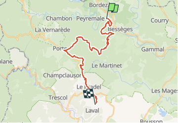

Length
28 km

Max alt
610 m

Uphill gradient
843 m
Km-Effort
39 km

Min alt
170 m

Downhill gradient
646 m
Boucle
No
Creation date :
2024-05-03 07:06:17.476
Updated on :
2024-05-03 17:03:32.159
9h36
Difficulty : Very difficult

FREE GPS app for hiking
 SityTrail
IGN / Geographical institutes
SityTrail Plus
The world is yours!
About
Trail Walking of 28 km to be discovered at Occitania, Gard, Bessèges. This trail is proposed by taguette.
Positioning
Country:
France
Region :
Occitania
Department/Province :
Gard
Municipality :
Bessèges
Location:
Unknown
Start:(Dec)
Start:(UTM)
586443 ; 4905798 (31T) N.
Comments