


brindas

MCARY
User
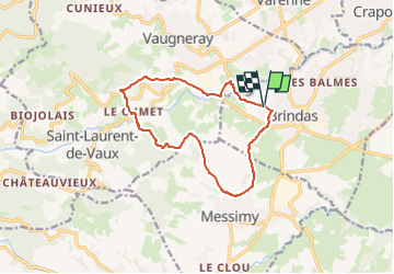

Length
12.3 km

Max alt
498 m

Uphill gradient
354 m
Km-Effort
17 km

Min alt
308 m

Downhill gradient
354 m
Boucle
Yes
Creation date :
2024-05-04 16:58:17.304
Updated on :
2024-05-04 16:58:18.679
3h52
Difficulty : Easy

FREE GPS app for hiking
 SityTrail
IGN / Geographical institutes
SityTrail Plus
The world is yours!
About
Trail Walking of 12.3 km to be discovered at Auvergne-Rhône-Alpes, Rhône, Brindas. This trail is proposed by MCARY.
Positioning
Country:
France
Region :
Auvergne-Rhône-Alpes
Department/Province :
Rhône
Municipality :
Brindas
Location:
Unknown
Start:(Dec)
Start:(UTM)
631139 ; 5064613 (31T) N.
Comments