


boucle 9

Isidore Hernandez 2
User
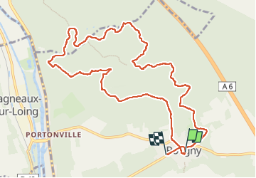

Length
12.1 km

Max alt
125 m

Uphill gradient
125 m
Km-Effort
13.8 km

Min alt
81 m

Downhill gradient
126 m
Boucle
No
Creation date :
2024-05-05 07:01:54.976
Updated on :
2024-05-05 11:33:26.458
4h30
Difficulty : Easy

FREE GPS app for hiking
 SityTrail
IGN / Geographical institutes
SityTrail Plus
The world is yours!
About
Trail Walking of 12.1 km to be discovered at Ile-de-France, Seine-et-Marne, Poligny. This trail is proposed by Isidore Hernandez 2.
Positioning
Country:
France
Region :
Ile-de-France
Department/Province :
Seine-et-Marne
Municipality :
Poligny
Location:
Unknown
Start:(Dec)
Start:(UTM)
481080 ; 5341207 (31U) N.
Comments