


les sources de l'Huveaune par Miette

bernir
User
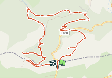

Length
9.5 km

Max alt
708 m

Uphill gradient
395 m
Km-Effort
14.8 km

Min alt
427 m

Downhill gradient
394 m
Boucle
Yes
Creation date :
2024-05-02 07:37:18.804
Updated on :
2024-05-05 15:11:18.798
5h45
Difficulty : Medium

FREE GPS app for hiking
 SityTrail
IGN / Geographical institutes
SityTrail Plus
The world is yours!
About
Trail Walking of 9.5 km to be discovered at Provence-Alpes-Côte d'Azur, Var, Plan-d'Aups-Sainte-Baume. This trail is proposed by bernir.
Positioning
Country:
France
Region :
Provence-Alpes-Côte d'Azur
Department/Province :
Var
Municipality :
Plan-d'Aups-Sainte-Baume
Location:
Unknown
Start:(Dec)
Start:(UTM)
724345 ; 4802382 (31T) N.
Comments