


Guirbaden

apa
User

Length
8.4 km

Max alt
563 m

Uphill gradient
307 m
Km-Effort
12.5 km

Min alt
316 m

Downhill gradient
322 m
Boucle
Yes
Creation date :
2024-05-05 16:36:13.207
Updated on :
2024-05-05 16:37:03.23
2h50
Difficulty : Difficult

FREE GPS app for hiking
 SityTrail
IGN / Geographical institutes
SityTrail Plus
The world is yours!
About
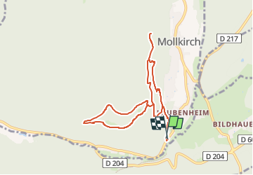
Trail Walking of 8.4 km to be discovered at Grand Est, Bas-Rhin, Mollkirch. This trail is proposed by apa.
Description
Autour du château
Positioning
Country:
France
Region :
Grand Est
Department/Province :
Bas-Rhin
Municipality :
Mollkirch
Location:
Unknown
Start:(Dec)
Start:(UTM)
380523 ; 5372193 (32U) N.
Comments